If someone were to ask you as a kid what cities would look like in 100 years your answer would probably involve incredibly tall buildings and flying cars. However, as we grow older and as flying cars don’t seem to be close to commercialization, it is becoming evident that the future will have a different look. Moreover, a rapidly growing population is knocking on our door, asking us to turn our attention away from riding a floating bike to work and toward more pressing problems. For the sake of accommodating more people, our cities are undergoing a rapid transformation, expanding into the surrounding areas. This progress often comes at a cost: sacrificing green spaces and fragmenting the habitat of a multitude of species.
Habitat fragmentation has led to a loss of as much as 75% of the original biodiversity in certain forests of Australia, the USA, and Brazil (for further reading see this and this article). It has become clear that it is not sustainable to keep expanding our cities without reconstructing part of the occupied habitats. However, this is not an arbitrary task. In order to build habitats where wildlife can thrive, certain conditions ought to be met and proper tools are needed. That is where network science comes into play, bringing insight into the needs of the wildlife living in our cities and helping policy makers assess the effectiveness of their green space proposals.
Is it not enough to build parks?
According to landscape ecology, it’s not. However, in order to understand why, we will need to introduce the concept of landscape connectivity. In ecology, landscape connectivity refers to how difficult it is for wildlife to move between different patches with resources. It’s worth noting that how connected a series of green areas is depends on the movement possibilities of the species that are considered. But why is connectivity important?
Well, think of a human colony, no larger than 100 people. Imagine that they are stuck in a small deserted island somewhere in the ocean. Their survival depends on this island providing everything they need. Moreover, if the population continues to grow, or if an event that affects their existing resources takes place, they won’t be able to supplement their demand. Now, if they had access to a boat and there were islands nearby, they could use the resources there to fulfill any needs that were not covered before, as well as possibly increase their consumption.
Translating back to the urban scenario, if the green spaces in our city are parks spread over the city and surrounded by urbanized land, for most species it is effectively the same as living in a deserted island. By constructing paths that connect the different patches, we are providing boats to the wildlife, helping them access different resources and interact with different populations. Therefore, making the ecosystems more resilient and the survival of the different species more plausible.
What does network science have to do with any of this?
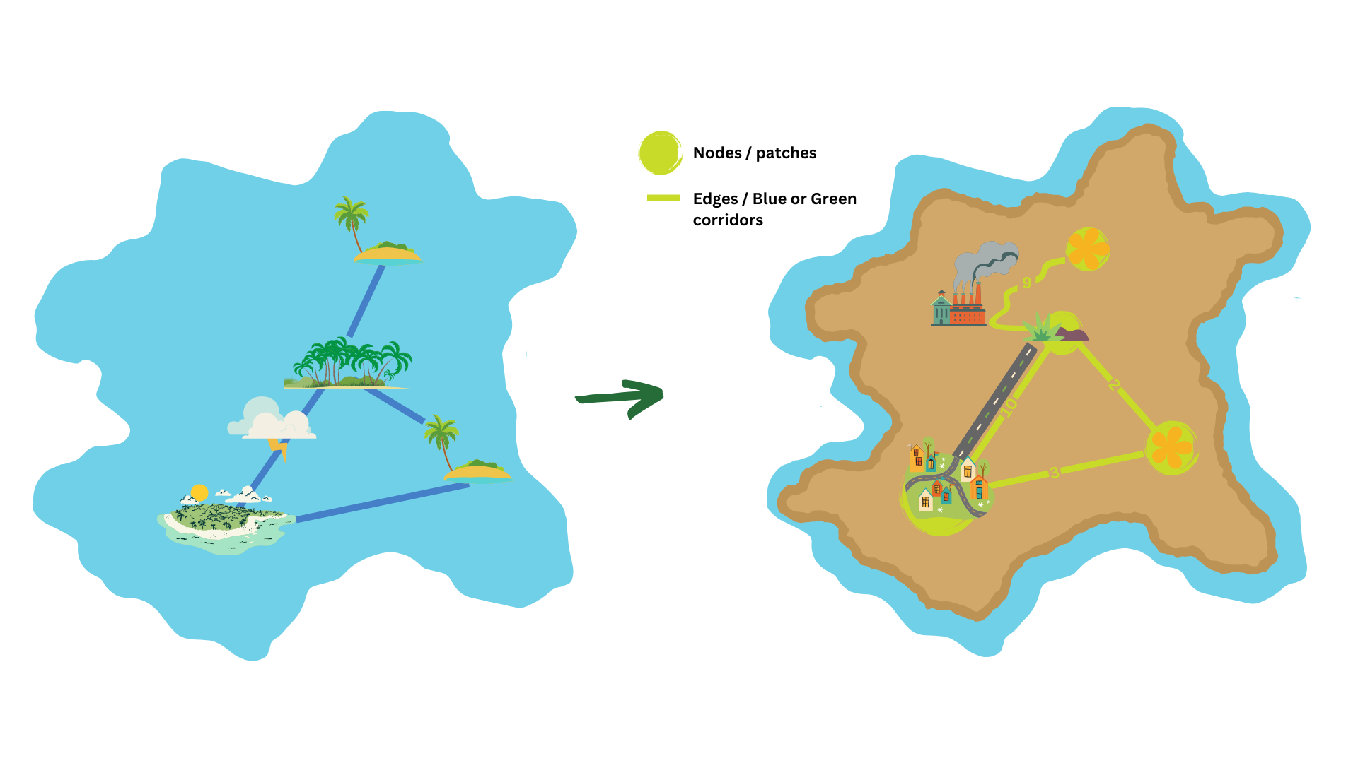
In the same way that one may build a network out of towns and the roads that connect them, a network of green spaces can be constructed. In this case, the green spaces are the nodes and the paths connecting them are the edges. These paths typically are patches of grass or masses of water like a river, depending on the species of interest and how they move. In our case, we will be dealing with a weighted network, in which the weights of the edges contain information about how hard it is to traverse that path. Such a network contains information on what habitats are available for the wildlife and how easily they can move around these spaces. Factors like distance or habitat suitability of the path influence how easy it is to go from one path to the other. Think again of the human colony on the deserted island. With their boat, they can now travel to the other islands and use their resources. However, if one of the islands was surrounded by strong currents, it may prove almost impossible for them to access it. In our network, the path connecting such an island with their home island would have a high weight; signaling that, although it is connected, traveling there is very hard.
As explained previously, one of the main concerns of the current layout of green spaces of cities is that they are disconnected. To quantify this, we can study the characteristics of our network. For example, the mean total weight of the paths between any two green spaces gives us information on how accessible it is to travel through the current setup. Constructing such a network also allows us to test different configurations helping to decide which paths will lead to better connected green spaces.
One of the main concerns of the current layout of green spaces of cities is that they are disconnected
Translating a map into a network
There isn’t a singular way to construct the network introduced in the previous section. Since we are considering the urban scenario, in order to assign travel difficulty values, we are mostly estimating which areas are more suitable for our species of interest and are less affected by human industrialization. The closer a patch is to potential danger, the less likely it is to be used by wildlife. Essentially, the main idea is that depending on the danger a threat poses and its range, it increases the travel difficulty of the land around it, and therefore decreases the likeliness of wildlife traveling through it. In the urban setting, industrialized land is considered a threat. Depending on the use of the land, different danger levels and ranges can be assigned. For example, a factory can be more harmful to a larger perimeter of the surrounding environment than a train rail. By considering these threats, we assign travel difficulty values to each piece of land.
Under the assumption that wildlife will take the easiest path between two points, we can compute the routes they are most likely to take between two green spaces and use these to construct our network. We will obtain a network for which all nodes are connected to each other, i.e. a complete network. In order to simplify it, we can consider different procedures. For example, since we assumed that wildlife would take the easiest path, edges directly connecting nodes can be removed if there exists another route between the two green spaces with a lower total travel difficulty. This network contains the information needed to assess the landscape connectivity of our city, helping us determine precisely in what areas improvement is needed.
Wielding the power of green space networks
Achieving a successful transformation to a sustainable urban environment across different cities around the world still remains a big challenge. Barriers dependent on local circumstances like unique social, technical, spatial, and environmental dynamics exist. However, by realizing the need for interventions, the concept of green infrastructure (GI), which considers engineered infrastructure under the context of ecological networks has emerged as the primary tool. For example, China experiencing deterioration within its mega-cities, is looking into GI with multifunctional benefits (the interested reader can have a look here). To overcome some of the challenges faced, the European Commission has been involved in finding and implementing the best strategies for GI since 2013 with the GREEN SURGE project and more recently with project NATURVATION in which diverse cities like Athens and Utrecht are part of.
In the case of Athens, the phenomenon of urban heat island (UHI) has intensified over the years as 80% of the city’s surface turned into built-up areas. A 2018 study identified the city as one of the most vulnerable among 571 European cities against future climate change impacts. Fortunately, Athens secured 5 million in funding from the European Investment Bank under the Natural Capital Finance Facility (NCFF) grant, the following year, to carry out its climate adaption strategies. The long-term plans involved reviving of forests and natural areas, creating open green spaces, and finally creating green corridors between different greened areas. By building the green networks, the city aimed to cater to a multitude of problems and opportunities like creating cool areas, improving air quality, increasing access to green spaces along with the mental health of its residents, preserving biodiversity, and securing a source of income from sustainable tourism.
Innovative methods like installing green roofs and vertical green spaces were also used to build up the green infrastructure (GI). Beyond this, the collaboration between the public-private sector and the local government was paramount to getting to a stage where the summer heat waves were manageable. In 2023, Athens experienced three heatwaves which were well-managed by raising awareness amongst the locals and visitors and having cooling measures in place. The city now aims to continue with its efforts in developing green corridors, implementing nature-based solutions, and rethinking every square meter of public space.
On the northern front of Europe, Utrecht, a city in the Netherlands, pays close attention to landscape defragmentation needs through the Netherlands Nature Network which consists of protected areas and ecological linkages. Any threat to ecological connectivity is solved by ‘the polluter pays’ model. As such is the case of the second largest contiguous reserve in the Netherlands, Utresche Heuvelrug, which was in danger of being fragmented by buildings and roads. Partnerships between the province of Utrecht and municipalities with concerned areas worked together to improve the spatial connectivity of the region. A technical and financially feasible action plan had to be drawn. This step identified 2 corridors that could make the green network more robust. As of now, work on one of the corridors is still underway.
Final outlook
The future of cities lies in prioritizing the preservation of green spaces, accounting for the danger habitat fragmentation poses. By considering the wildlife of our environment as beings with basic needs as us, we can begin to understand where we are failing. Network science can help assess the current situation and serve as a tool for policy makers to determine what changes need to be made in order to make urban areas more suitable for wildlife.
The images in this article where taken from Pixabay.
We want our guts to be filled with a diverse range of mutually beneficial and competitive interactions, a perfect blend of friends, frenemies, and enemies to keep our guts active and body on its toes. Read how networks can help understand these interactions!
During our teenage years, everything changes. It’s no surprise that our brain does too. But how do we make sense of this transformation? Is there a way to quantify it? Networks might just be the answer.
The scientific world would not be what it is today without normal distribution. It is the foundation of many statistical models for several good reasons. Most importantly, it appears commonly in nature. But this is only the tip of the iceberg.
Rafael Prieto-Curiel is a mathematician and a faculty member at the Complexity Science Hub in Vienna, Austria. His research focuses on crime, mobility, migration and urban dynamics. We interviewed Rafael to learn about his story.